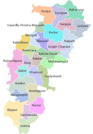
Chhattisgarh (CG) District Name List
Chhattisgarh is the tenth largest state of India with an area of 135,194 square kilometres. The population of Chhattisgarh state is about 2.55 crores, thus in terms of population, Chhattisgarh is the sixteenth largest state of the country. The native language of the people of Chhattisgarh is Chhattisgarhi. The present Chhattisgarh, separated from the state of Madhya Pradesh, came into existence on 01 November 2000.
Chhattisgarh is an important center of India from the point of view of production of electricity and steel. About 15% of the total steel produced in India is in Chhattisgarh: Chhattisgarh state borders with seven states viz. Madhya Pradesh, Maharashtra, Andhra Pradesh, Telangana, Orissa, Jharkhand and Uttar Pradesh. touches the state.
The capital of the state of Chhattisgarh is Raipur, which is mainly the center of business, economy, and administration. Originally popular in the state of Chhattisgarhi, but mainly Hindi is used, the boundaries of the state of Chhattisgarh, also known as Chhattisgarh rice bowl (meaning rice bowl), are in the northwest, Maharashtra in the west, Andhra Pradesh in the south, It touches Orissa in the East, Jharkhand in the North East and Uttar Pradesh in the North.
Chhattisgarh 33 DistrictName List: Balod, Baloda Bazar, Balrampur, Bastar, Bemetara, Bijapur, Bilaspur, Dantewada, Dhamtari, Durg, Gariaband, Gaurella-Pendra-Marwahi, Janjgir-Champa, Jashpur, Kabirdham, Kanker, Kondagaon, Khairagarh-Chhuikhadan-Gandai, Korba, Koriya, Mahasamund, Manendragarh-Chirmiri-Bharatpur, Mohla-Manpur-Chowki, Mungeli, Narayanpur, Raigarh, Raipur, Rajnandgaon, Sarangarh-Bilaigarh, Shakti, Sukma, Surajpur and Surguja
Chhattisgarh (CG) District Map List PDF Download – Click Here
