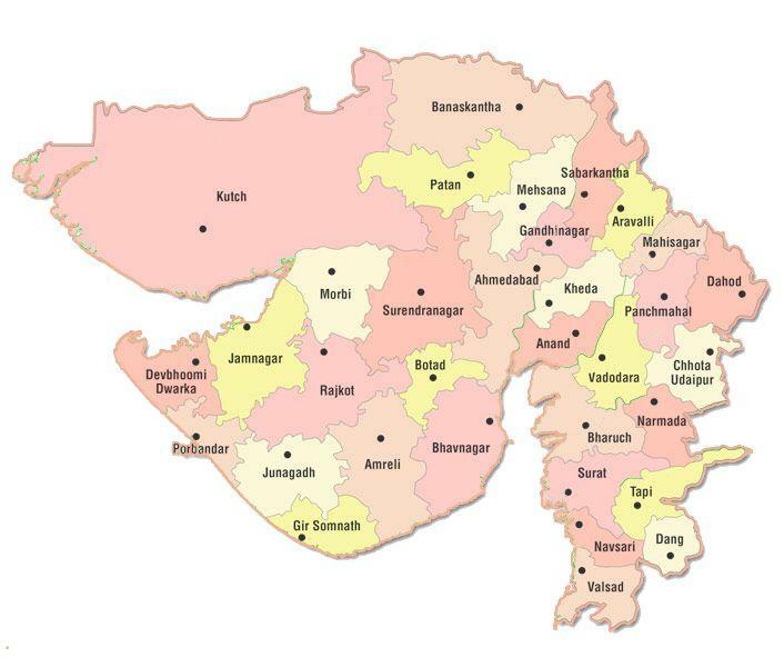
Gujarat (GJ) District Name List
Gujarat – The Land of the Legends, stands bordered by Pakistan and Rajasthan in the north east, Madhya Pradesh in the east, and Maharashtra and the Union territories of Diu, Daman, Dadra and Nagar Haveli in the south. The Arabian Sea borders the state both to the west and the south west.
Rock Inscriptions in the Girnar Hills show that the Maurya Emperor Ashoka, extended his domain into Gujarat in about 250 BC. With it’s fall, the control of the region came under the Sakas or Scythians.
During the 900’s the Solanki Dynasty came to power and Gujarat reached it’s greatest extent.
Then followed a long period of Muslim rule. Ahmed I, the first independent Muslim ruler of Gujarat, found Ahmedabad in 1411. The Mughal Emperor Akbar conquered Malwa and Gujarat in 1570s.
The British East India Company set its first footsteps in Surat in 1818 and the State came in control of their rule. In 1600’s, the Dutch, French, English and Portuguese had all established bases along the coast of the region.
Gujarat was divided into princely states. After the Indian Independence in 1947, all of Gujarat except Saurashtra and Kutchh became part of Bombay State until May 1, 1960, when the Government split Bombay state into the States of Maharashtra and Gujarat.
Ahmedabad became the chief city of the new State and housed the State Government Offices. They remained there until they were transferred to Gandhinagar in 1970. Major Cities & Places
Gujarat 33 Districts Name List
Gujarat Districts Name List: Ahmedabad, Amreli, Anand, Aravalli, Banaskantha (Palanpur), Bharuch, Bhavnagar, Botad, Chhota Udepur, Dahod, Dangs (Ahwa), Devbhoomi Dwarka, Gandhinagar, Gir Somnath, Jamnagar, Junagadh, Kachchh, Kheda (Nadiad), Mahisagar, Mehsana, Morbi, Narmada (Rajpipla), Navsari, Panchmahal (Godhra), Patan, Porbandar, Rajkot, Sabarkantha (Himmatnagar), Surat, Surendranagar, Tapi (Vyara), Vadodara and Valsad
Gujarat District Map PDF Download – Click Here
