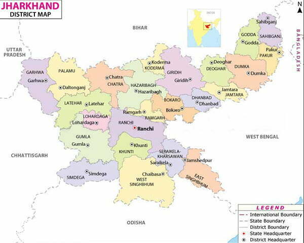
Jharkhand (JH) District Map List
The 28th state of the Indian Union was brought into existence by the Bihar reorganization Act on November 15,2000- the birth anniversary of the legendary Bhagwan Birsa Munda. Jharkhand is famous for its rich mineral resources like Uranium, Mica, Bauxite, Granite, Gold, Silver, Graphite, Magnetite, Dolomite, Fireclay, Quartz, Fieldspar, Coal (32% of India), Iron, Copper (25%of India) etc. Forests and woodlands occupy more than 29% of the state which is amongst the highest in India.
| FACT SHEET (Data As Per 2011 Census) | |||
| Population : | 32,988,134 | No. of Divisions : | 5 |
| Male Population : | 16,930,315 | No. of Districts : | 24 |
| Female Population : | 16,057,819 | No. of Sub divisions : | 38 |
| Density of Population : | 414 persons / Sq. KM | No. of Blocks : | 264 |
| National Highways : | 1844 KMs | No. of Villages : | 32620 |
| State Highways : | 6880 KMs | Total Geographical Area : | 79.70 Lakh Hect |
- Elephant (Elephas Maximus Indicus): State Animal
- Koel (Eudynamys Scolopaceus): State Bird
- Palash (Butea Monosperma): State Flower
- Saal (Shorea Robusta): State Tree
History
The region enshrouded in the hills and forests inaccessible to a large segment of people. The tribes of this state are living here from thousands of years and not much changed in their life and culture over the ages baring last few decades. Many scholars now believe that the language used by tribes in the state of Jharkhand is identical to the one used by Harappan people. This has led to a great interest in the deciphering of Harappan inscriptions using rock paintings and language used by these tribes. For a greater part of Vedic age, Jharkhand remained obscured. During the age of Mahajanpadas around 500 BC, India saw the emergence of 16 large states who controlled the entire Indian subcontinent. The supremacy of the janpads were often decided by the power of swords and bows and ax and other weapons. The region around Jharkhand was extremely rich in its mineral resources including iron and the janpad that controlled this region, Magadha, eventually controlled most of the country. The power of Magadha continued to occupy central state in Indian subcontinent for a long time and saw the emergence of mighty empires such as Mauryas and Guptas. After the end of last big Hindu empire of Guptas, India saw emergence of a number of numerous regional powers who tried to control this region. Same was the case with Muslim Sultans of Delhi and their feudatories in Bengal, who tried to control this mineral-rich area. British identified this region as a great source of raw material for their booming industries back home and to exploit the region to its full potential, established a vast network of railway line. Calcutta was developed as a major port to export raw materials from this region to England. Birsa Munda (1875-1900)and Sidho and Kanho are the legendary heroes of the tribals of this state who fought against the oppressive rule of the British government. Birsa Munda, now regarded as god, fought for the tribals natural right over forests and land that was mercilessly being acquired by the British for exploitation. After a long fight, Birsa Munda was captured by the British authorities and died in prison. Sidho and Kanho were another set of revolutionaries among the tribals, now regarded as a tribal heroes. For a long time, Jharkhand remained as a part of Bihar, but after Indian independence, the demand for a separate state of tribals started gaining momentum. In the last fifty years, the tribes of this region fought against the hegemony of Northern Bihar, a region that gained from the mineral deposits of this region like anything. Jharkhand became a state under the Republic of India on November 15, 2000 and now it is poised for a great leap forward.
Geography
Most of the state lies on the Chota Nagpur Plateau, which is the source of the Koel, Damodar, Brahmani, Kharkai, and Subarnarekha rivers, whose upper watersheds lie within Jharkhand. Much of the state is still covered by forest. Forest preserves support populations of tigers and Asian Elephants. Soil content of Jharkhand state mainly consist of soil formed from disintegration of rocks and stones, and soil composition is further divided into: Red soil, found mostly in the Damodar valley, and Rajmahal area Micacious soil (containing particles of mica), found in Koderma, Jhumri Telaiya, Barkagaon, and areas around the Mandar hil Sandy soil, generally found in Hazaribagh and Dhanbad Black soil, found in Rajmahal area Laterite soil, found in western part of Ranchi, Palamu, and parts of Santhal Parganas and Singhbhum.
Climate
There are three well-defined seasons in Jharkhand. The cold-weather season, from November to February, is the most pleasant part of the year. High temperatures in Ranchi in December usually rise from about 50 °F (10 °C) into the low 70s F (low 20s C) daily. The hot-weather season lasts from March to mid-June. May, the hottest month, is characterized by daily high temperatures in the upper 90s F (about 37 °C) and low temperatures in the mid-70s F (mid-20s C).
Jharkhand (JH) 24 District Name List:
Bokaro, Chatra, Deoghar, Dhanbad, Dumka, East Singhbhum, Garhwa, Giridih, Godda, Gumla, Hazaribag, Jamtara, Khunti, Koderma, Latehar, Lohardaga, Pakur, Palamu, Ramgarh, Ranchi, Sahibganj, Seraikela – Kharsawan, Simdega, West Singhbhum


 Kendriya Vidyalaya Admission 2024-25 for Class 1 [Apply Online from 1.1.2024 to 15.4.2024]