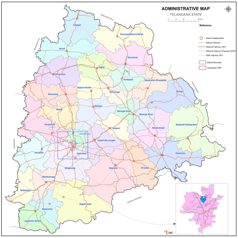
Telangana (TS) District Map List
Telangana is the 29th state of India, formed on the 2nd of June 2014. The state has an area of 1,12,077 Sq. Km. and has a population of 3,50,03,674. The Telangana region was part of the Hyderabad state from Sept 17th 1948 to Nov 1st 1956, until it was merged with Andhra state to form the Andhra Pradesh state.
After decades of movement for a separate State, Telangana was created by passing the AP State Reorganization Bill in both houses of Parliament. Telangana is surrounded by Maharashtra and Chhattisgarh in the North, Karnataka in the West and Andhra Pradesh in the South and East directions. Major cities of the state include Hyderabad, Warangal, Nizamabad, Nalgonda, Khammam and Karimnagar.
Telangana Capital City: Hyderabad
Telangana Area: 112,077 Sq. Kms.
Telangana Districts: 33
Telangana Households: 83.04 Lakhs
Telangana Population: 350.04 Lakhs

33 District in Telangana Name List
| SI.No | District Name |
| 1 | ADILABAD |
| 2 | BHADRADRI KOTHAGUDEM |
| 3 | HANUMAKONDA |
| 4 | HYDERABAD |
| 5 | JAGTIAL |
| 6 | JANGOAN |
| 7 | JAYASHANKAR BHOOPALPALLY |
| 8 | JOGULAMBA GADWAL |
| 9 | KAMAREDDY |
| 10 | KARIMNAGAR |
| 11 | KHAMMAM |
| 12 | KOMARAM BHEEM ASIFABAD |
| 13 | MAHABUBABAD |
| 14 | MAHABUBNAGAR |
| 15 | MANCHERIAL |
| 16 | MEDAK |
| 17 | MEDCHAL-MALKAJGIRI |
| 18 | MULUG |
| 19 | NAGARKURNOOL |
| 20 | NALGONDA |
| 21 | NARAYANPET |
| 22 | NIRMAL |
| 23 | NIZAMABAD |
| 24 | PEDDAPALLI |
| 25 | RAJANNA SIRCILLA |
| 26 | RANGAREDDY |
| 27 | SANGAREDDY |
| 28 | SIDDIPET |
| 29 | SURYAPET |
| 30 | VIKARABAD |
| 31 | WANAPARTHY |
| 32 | WARANGAL |
| 33 | YADADRI BHUVANAGIRI |
Telangana (TS) District Map PDF Download (English Version) – Click Here


 Kendriya Vidyalaya Admission 2024-25 for Class 1 [Apply Online from 1.1.2024 to 15.4.2024]